 Jacob Cruser: It was June 2011 and my friend Matt King had recently moved out east to Northeast Oregon. His desire to explore had him seeking out whitewater runs in this not often sought out area of Oregon. Map work and good fortune had it that he had landed on a gold mine of creeks. The geology and steep terrain proved to create some quality streambeds.
After a trip to Idaho, Matt and I loaded up and headed out to see what the creeks of the Wallowa's would look like with water in them. Our first destination was a more challenging than we wanted to bite off, so we kept traversing the southern side of the mountain range via arterial roads.
After a 22 mile gravel detour around a 3 mile section of closed road and the first of two bobcat sightings, we made it up to a promising fork that had plenty of water. We saw a massive granite face across the stream that was enough to get us to hike up the trail a ways hoping the stream would lose its sediment laden character farther up when this granite intersected the stream. We made it about half mile before deciding it would be more promising to head elsewhere. 4 years later a return trip confirmed the EF of Eagle Creek was worth paddling.
Back to the time at hand and Matt had a lead on a promising section of the main fork of Eagle Creek, so we consulted the Gazeteer and found a put in and take out.
The river was running clear, but it was obvious once on it that the water was high. To stop we were using the time-tested practice of using slow spots near the shore with shrubs to grab onto. We almost portaged a large log jam where we had to stop 100 yards upstream as there were no more eddies and it looked like it blocked the whole river. I portaged high, Matt low. I was able to get to another vantage point from my elevated perch and informed Matt there was in fact a very clear route in the boat.
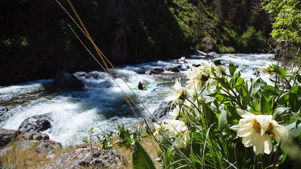
We came to some odd ponds on river left that signaled that we were about to enter the gorge. The next half mile was a little stressful, but mostly fun. It was endless class three and four boulder boofs and plenty of splashes. The stress came from not knowing what we would find around any given corner and the concern that we might have trouble stopping if we needed to.
Not too far into the fun stuff we did need to scramble to shore above a large rapid with big boulders. Matt gave it a long look, but in the end we both walked it on the left. The next few hundred yards below that rapid was quality class IV.
More class III-IV and intermittent easy floating lead to a campground, our take out, and some nice people willing to help us shuttle. Another local mentioned he hadn't seen the river this high at this time of year his entire life.
I returned to Eagle Creek 4 years later with Michael Freeman at lower flows. The trip was uneventuful, we both walked the big one again. However, this time we thought we would be clever and use Michael’s Mountain bike to run shuttle along the riverside trail (the shuttle road goes far away from the creek and isn’t practical for a bike). We thought it would take about an hour so I continued paddling downstream to see what was there while Michael biked. I enjoyed the change in scenery as the creek left the forested upper reaches and transitioned into high desert ranchland. After an hour or so I figured I should take the next opportunity to take out. 30 minutes later I hadn’t found anything public but felt I needed to get out before Michael passed by on the road and this turned into a debacle. I schwacked up through a steep cow pasture, then climbed a hill above the road to sit in the sun and wait. Another couple hours goes by and I’m a bit worried that Michael isn’t there yet. I talk to a rancher who offers me a ride up, and about 15 minutes up the road Michael’s car is visible heading towards us and I wave him down. Turns out, the trail is not conducive to biking. He carried the bike more than road it, and had taken a deserved break for a tick cleans and swim before driving back downstream. Guess we will bring two cars next time. (read the full story)
 Zach
Collier: Dirt roads follow most of Eagle Creek allowing easy access
for whitewater paddlers. After looking at topo maps we found a section of
the creek that veers away from Eagle Creek Road and we chose to paddlethere.
We put-in just below the NF-7015 bridge and quickly enjoyed the nearly continuous
whitewater. There was a tricky log portage early on which had us worried
about more logs downstream. There was more wood to watch out for but it was
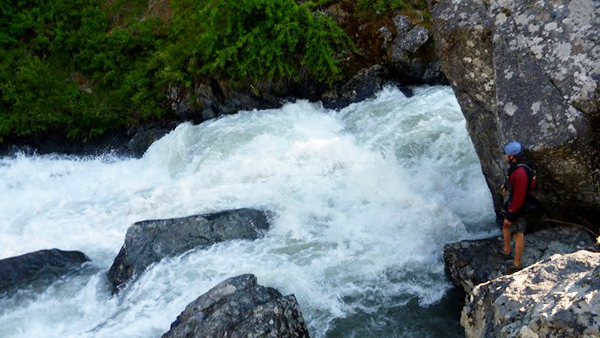
mostly clear for the rest of the run. We came upon a huge rapid with logs
at the top that we were easily able to portage using a trail on the left.
Below the portage we paddled a fun Class IV rapid and more continuous whitewater
all the way to the Little Eagle Creek confluence.
Zach
Collier: Dirt roads follow most of Eagle Creek allowing easy access
for whitewater paddlers. After looking at topo maps we found a section of
the creek that veers away from Eagle Creek Road and we chose to paddlethere.
We put-in just below the NF-7015 bridge and quickly enjoyed the nearly continuous
whitewater. There was a tricky log portage early on which had us worried
about more logs downstream. There was more wood to watch out for but it was
mostly clear for the rest of the run. We came upon a huge rapid with logs
at the top that we were easily able to portage using a trail on the left.
Below the portage we paddled a fun Class IV rapid and more continuous whitewater
all the way to the Little Eagle Creek confluence.